
History

Emerald is located on the Nogoa River 263 km west of Rockhampton and 909 km from Brisbane (via Rockhampton). It is a thriving rural centre with a good sized TAFE college, a rural training college, a large regional hospital, a large number of farm machinery sales outlets, a cotton gin, a huge irrigation dam and an airport.
Established in 1879, it has slowly grown to be the major regional centre of the Central Highlands and the gateway to the Central Western district.
The Capricorn hinterland contains the largest sapphire gemfields in the world.
Like most of the towns of the Central Highlands, Emerald claims that Ludwig Leichhardt was the first European in the area. It has a better claim than most (with the obvious exception of Taroom) in the sense that Leichhardt named the nearby Comet River after seeing a comet and he inscribed the word ‘Dig’ on a tree by the banks of the river.
After Leichhardt’s glowing reports on the fertility of the region, land was taken up and in 1860 one of the local properties was named ‘Emerald Downs’ by the area’s first settler P. F. MacDonald who was impressed with the lush greenness of the district after rain.
In the 1860s both gold and copper were found in the area and there was a brief flurry of interest.

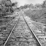
The town was established in 1879 as a base for the railway line which was reaching out from Rockhampton into the Central West.
Unfortunately, little is left of Emerald’s early history as it was ravaged by major fires in 1936, 1940, 1954 and 1968.
Emerald would have continued as a small town had it not been for a decision made in 1948 by the British Food Corporation to grow sorghum in the area. This highlighted the suitability of the local soil to crop growing.
To strengthen the agricultural base of the area the huge Fairbairn Dam, located south of the town, on the road to Springsure, was built in 1972 with a storage capacity of 1, 440, 000 ML. This facilitated the shift of the shire’s economic focus from cattle to crops.
The region now produces over 25% of Queensland’s cotton.
Lake Maraboon, which has been dammed by Fairbairn Dam, is vast and its waters have become a popular leisure haunt for people in the region.

Source: Sydney Morning Herald